Welcome to the Whyte Ridge Interpretive Trail Project!
After many years of planning and effort, discussed in our background page, we’re pleased to introduce our interpretive trail project. Hopefully this 0.5 km trail winding north through the community centre site provides you with an interesting alternative if you’re not enjoying hockey, basketball, soccer, or our play structure.
The trail features a 100 m2 butterfly-shaped butterfly garden, with a viewing bench and wheelchair accessibility to almost 1,000 plants, including numerous butterfly host plants among an array of attractive species. The trail also includes a stretch of more than 2,000 m2 of tall grass prairie restoration habitat, and a line of elm trees planted as a tribute to their historic relationship with Winnipeg streets. Tree and shrub species native to southern Manitoba have been planted around much of the site perimeter, and interpretive signage at key locations provides information on both the natural/cultural history and ecology of the area.
If you’re planning on taking a walk or bike ride along the trail, perhaps on your way to visit the FortWhyte Alive trail to the north of our site, we’ve provided an overview and some information on our trail to help make the experience a little more interesting. Over the next few months we’ll be adding photographs and descriptions of the various plants you can expect to see when you visit.
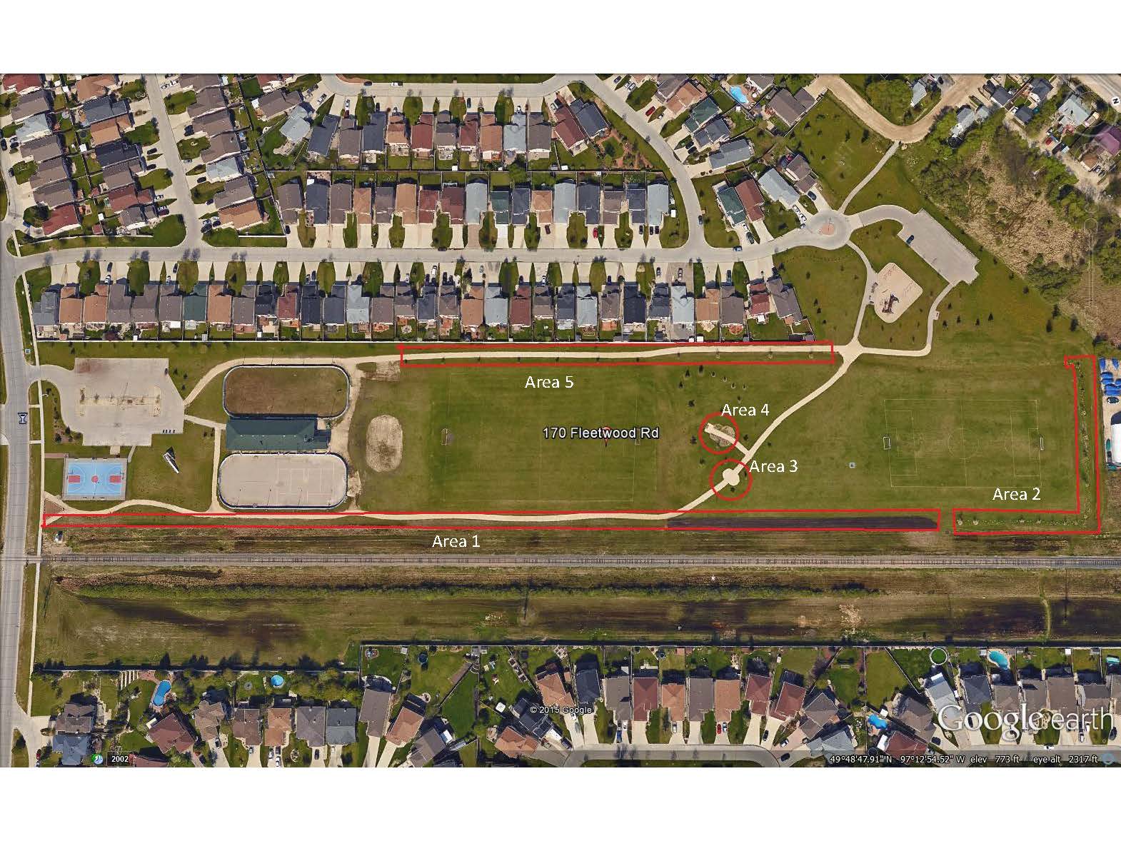
The attached map shows the location of our community centre and the interpretive trail. You’ll notice that it’s organized into the following areas:
[toc]
Background
In the fall of 2015 the Whyte Ridge Interpretive Trail finally became fully functional – a vision that took almost 10 years to implement. The Trail runs across the Whyte Ridge Community Centre (WRCC) site, located in the northwest corner of the community of Whyte Ridge. As shown in the map it is connected, by footbridge and a small portion of Front Street, to the Fort Whyte Alive facility to the north, across McGillivray Boulevard.
The Trail concept originated in late 2005, as the WRCC volunteer Board of Directors began to develop plans to finally landscape the property. While the property was purchased by the City of Winnipeg in 1986, by 1998 only the building, parking lot and a hockey pen had been built. Due in large part to the assistance of City Councillor Bill Clement, by 2007 a major landscaping project was in full swing, with more than $500,000 in funds being used in the development of the 4.37 ha (10.8 acres) property, including two soccer pitches, a basketball court, a pleasure skating rink, a play structure, and walking trails. Funding sources included the Manitoba Hydro Forest Initiatives Fund and the Evergreen Foundation Fund, but primarily the City of Winnipeg Land Dedication Reserve Fund, as well as a multi-year community fundraising campaign, involving events such as summer festivals and golf tournaments.
As part of this landscaping project, consideration was given to developing some interesting interpretive/educational features that might appeal to local schoolchildren and residents not participating in community sports, and it became apparent that WRCC was well-positioned to offer this option. In addition to its proximity to the Fort Whyte Alive facility to the north, used regularly for visits by the two schools in the community, a segment of the TransCanada Trail (arguably the world’s largest recreation pathway) runs through the WRCC site. When Fort Whyte Alive opened an entrance on its southern end in 2006, many Whyte Ridge residents began to access the Fort Whyte Trail network through the WRCC property.
The project fell by the wayside in 2009 as several WRCC Board members moved on to other endeavors, but in 2013 the plan was updated and a new phase of implementation began. Initial interpretive concepts involved several historic events in the area, and the relationship between railways and native prairie. More recently, the project has incorporated aspects of Aspen Parkland, the relationship between elms and Winnipeg streets, and a butterfly garden. The project includes benches and interpretive signs describing the various interpretive features will be located along the trail.
Area 1 – Tall Grass Prairie
The presence of the nearby a Canadian Pacific Railway spur line in conjunction with existing native prairie grassland habitat immediately to the east of the WRCC property provides an interesting interpretive feature and is what inspired the interpretive trail project. When vast tracts of native prairie in North America were settled by Europeans the land was used for farming and fires were prevented wherever possible. Wildfires are a natural part of the prairie ecology and reduce encroachment of trees and rejuvenate prairie soils. Over the past 100 years, with the spread of agriculture and control of fires, areas of native prairie have been drastically reduced. The tall-grass prairie (with species including big bluestem, switch grass, Indian grass, little bluestem, Canada wild rye and northern wheatgrass), is now one of the most endangered habitats in North America. One of the few types of areas where native prairie was sustained surrounded the railways, particularly as fire was often used as a means to control vegetation on railway tracks. The WRCC Board has been working closely with Native Plant Solutions to establish an area of tall grass prairie along the entire eastern side of the property.
On May 11 2017, Native Plant Solutions organized a controlled burn of the prairie area, which served to rejuvenate the area. Here is a short video of the event:
The tall grass prairie area can be divided into the following four zones:
- 1a Railway Zone
- 1b Trailhead
- 1c South Zone
- 1d North Zone
1a Railway Zone
Looking east from the site towards the railway track, visitors to the site will likely see grass species typical of tallgrass prairie, such as big bluestem (more than a metre tall) and June grass (20-30 cm tall with a whitish grass flower) to the northeast end of the site, interspersed with wildflowers such as Canadian anemone (25-35 cm in height with loonie-sized white flowers) and northern bedstraw (30-40 cm with larger clusters of small white flowers), as well as wild roses, dogwoods, and wild strawberry. Later in the summer species such as yarrow, Maximilian sunflower and various aster species begin to flower.


1b Trailhead
The first aspect of the interpretive trail seen when entering the site from its south east end on Fleetwood Road is a prairie wildflower trailhead garden. In addition to native grasses, the trailhead garden at the Fleetwood entrance includes several flower species such as prairie coneflower, wild lewis flax, upland white aster, New England aster, Maximillian sunflower, and stiff sunflower, as well as purple prairie clover.

1c South Zone
The southern portion was established in 2009. The area has been row-seeded with grass species such as little bluestem, June grass, buffalo grass, side-oats grama, Lewis blue flax and several wheatgrass species, as well as flowers such as purple prairie clover. Unfortunately there was no active management after installation and the area was unintentionally mowed on a regular basis. While mowing can benefit prairie habitat if done appropriately as it is somewhat similar to bison grazing, the lack of active management at the site allowed the introduction of several non-native species such as bluegrass, clover, redtop, quack grass and Canada thistle, which were found throughout the zone in a summer 2015 survey. In 2015 ongoing active management was initiated to remove and control these species, and this will continue through 2016, likely involving a controlled burn in the late spring. Fire is a natural prairie process and the species are adapted to fire. Burning the dead material releases nutrients into the soils and the black scorched area helps the sun to warm the soil and cause germination of seeds. There are even some species where the burning of their hard seed coats helps them to germinate.
Despite the presence of non-native species, many prairie species were observed prior to the start of the management activities in 2015. Switch grass was found throughout the south zone, sometimes comprising half of the cover in any given area. Switch grass is a hardy, deep-rooted self-seeding grass that is versatile and adaptable – likely contributing to its persistence since 2009. There are also pockets of classic tall grass prairie species such as big bluestem and Indian grass in the southern portion and northern portion of the zone, as well as green needlegrass and tufted hair grass, with patches of anemone and wild strawberry towards to northern part of the zone, and northern wheatgrass in the south portion. June grass, tall mana grass and sedge were found in the central portion, with slough grass and narrow-leaved cattail found in the wetter areas adjacent to the hockey pen.

1d North Zone
The northern portion was installed in 2014. As with the southern portion, the seed used includes grass species such as little bluestem, June grass, buffalo grass, side-oats grama, Lewis blue flax and several wheatgrass species, as well as flowers such as purple prairie clover. In the first year a wheat cover crop was planted, to serve as a thermal cover, retaining moisture and stopping the area from getting too dry, or eroded from the wind. Over time, the new prairie area should blend in with the existing prairie beside the rail tracks.


Area 2 – Native Trees
In addition to adding some topography to break up the linear (500m x 90m) shape of the property, efforts have been made to “soften” the site using native trees as visual and acoustic barriers to adjacent residential and commercial property. During the planting process an attempt was made to use largely native species reflective of Aspen Parkland, such as Saskatoon, willow, chokecherry, aspen, pincherry, cottonwood, basswood, and maple. The northern portions of the property will be left to naturalize over time.

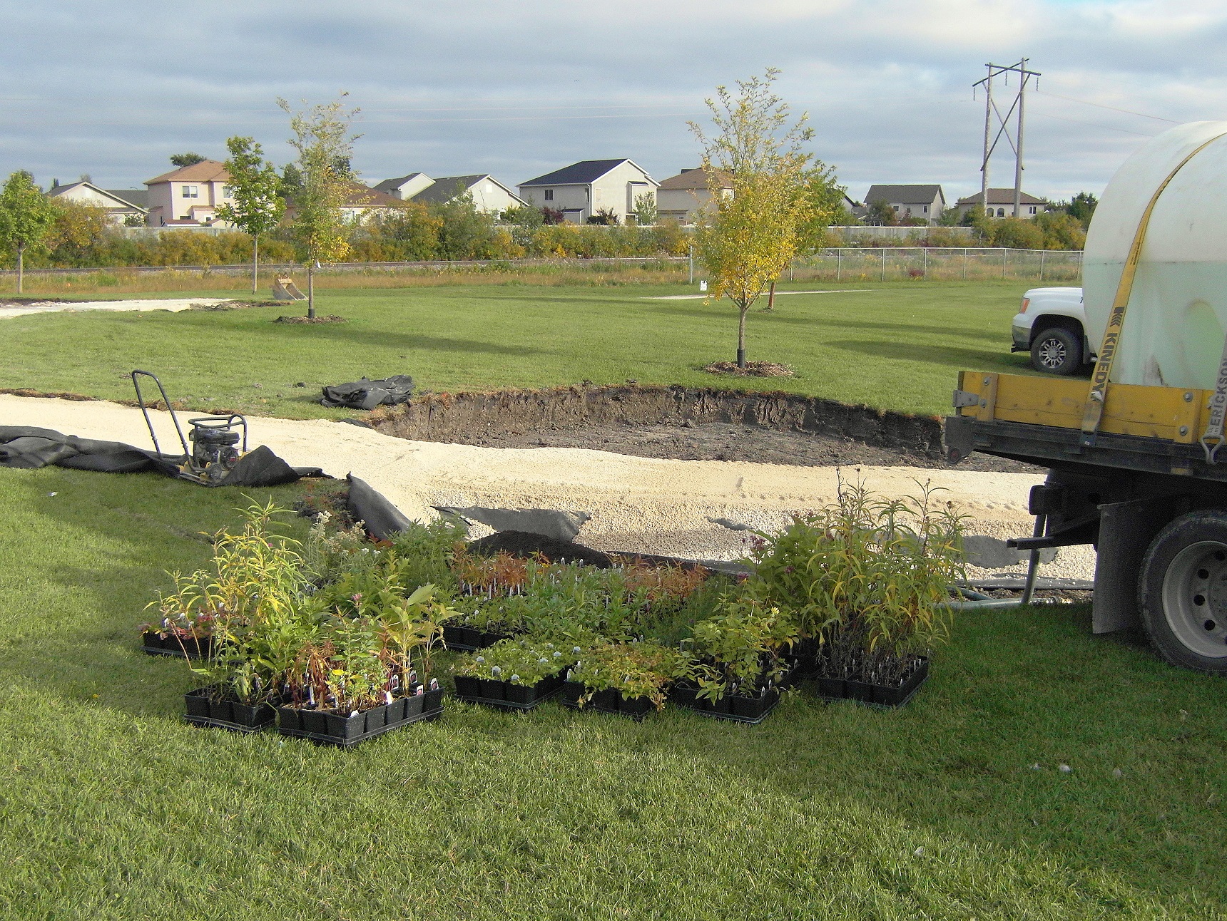
In June 2017, several additional saplings were planted on the northwest corner of the site, as a natural fence, in an effort to deter mowing and facilitate naturalization and encroachment of surrounding willow trees:

Area 3 – Interpretive Node
As indicated, a node with a bench has been established in the middle of the WRCC site with signage to illustrate several important historic events that occurred in the area.
The Battle of Fort Whyte
Whyte Ridge is named after William Whyte, who led a “bloodless battle” over railway rights in 1888 on land that is adjacent to the WRCC site. On October 20, 1888 more than 300 angry Winnipeggers rallied behind the provincial chief of police and were rushed to a point some five miles southwest of the City (near the existing Community Centre property) to do battle with an equal number of Canadian Pacific Railway employees, many of them armed with pick-axes, who were determined to keep another rail line from crossing the CPR right of way. The new lines would have to cross already existing trackage owned by the CPR at, Fort Whyte, Headingley and Morris. The dramatic event was an episode in Manitoba’s fight to break the 20-year monopoly granted the CPR syndicate in 1881, giving it control over all railway building south of the main line. Manitoba eventually won that battle in the courts, but before it did, there were several conflicts such as the one near the Community Centre.
The Stopping of the Survey
Nineteen years before the Battle of Fort Whyte the WRCC area was where Louis Riel, with a mounted patrol of unarmed Metis, led the Stopping of the Survey. According to the Manitoba Historic Resources Branch of Manitoba Culture, Heritage and Tourism, in 1869 a mounted patrol of unarmed Métis led by Louis Riel forced Canadian government surveyors to halt their work in the southern parishes until negotiations had taken place between the inhabitants of Red River Settlement and the Canadian Government. This first public act of the Red River Resistance led ultimately to the creation of the new province of Manitoba. In 1995 a provincial commemorative plaque was installed in Don Smith Park, adjacent to a play structure, several hundred metres south of the WRCC. The plaque was vandalized several years later and then removed from the site. Through discussions with Historic Resources Branch it was agreed that the WRCC would be a suitable location to have the plaque re-installed, as it is actually closer to the location of the event.

Area 4 – Butterfly Garden
One of the most recent aspects of the Interpretive Trail Project is the 100 m2 butterfly-shaped butterfly garden, funded in part by the Monarch Butterfly Conservation Campaign, sponsored by Pegasus Publications Inc. The garden was developed over the course of 2014 and 2015, and with a bench and wheelchair accessibility, it contains numerous butterfly host plants among an array of attractive species. Almost 1,000 plants have been installed, including species of sunflower, milkweed, aster, clover, blazing star, coneflower and goldenrod. Some butterfly species, such as the monarch butterfly, are experiencing habitat loss that is threatening their status. The garden is a Certified Monarch Waystation (www.MonarchWatch.org) as a small way of helping to preserve this particular species.
The garden has been designed to address the various butterfly species-specific needs during the time they arrive in Canada in June to early fall when they begin to migrate to overwinter in the south. Habitat requirements include sunshine, food sources for adults and larvae, a water source, and shelter from the wind. The garden has been placed in a bowl-shaped depression in the topography and surrounded by dogwood shrubs to provide wind protection. It faces south to receive good exposure to the sun. Milkweed plants are key species for butterflies, as the nectar provides food for adults and the leaves provide food for the caterpillars. The butterfly garden contains both swamp milkweed and whorled milkweed, which are preferred host plants for the monarch butterfly. The garden also contains heart leaf Alexander and golden Alexander, known to be host plants for black swallowtail butterflies, and pearly everlasting, a preferred host plant for painted lady butterflies. Other nectar plants in the garden include species such as low goldenrod, showy goldenrod, black-eyed susan, New England aster, many flowered aster, flat top aster, coneflowers, ironweed, joe-pye weed, wild bergamont, meadow blazing star, dotted blazing star, gallardia, white prairie clover, purple prairie clover, and giant hyssop. The fact that monarch, black swallowtail, painted lady and red admiral butterflies have already been seen in the garden shows that it’s working well so far! The new garden was formally enjoyed on July 4 2015, when about 160 people visited the site as part of a Nature Manitoba tour.


Butterfly Garden Development
Plans for the butterfly garden began in early 2014, with the assistance of local volunteer Kelley Liebzeit, a Master Gardener in training, who had experience in developing and maintaining a butterfly garden in her back yard. By mid-September 2014 the garden bed was dug, a path installed and 470 native plants were installed. In June 2015 an additional 440 plant plugs were installed, and an interpretive sign was developed and installed in September 2015. In addition to Kelley numerous volunteers have spent many hours installing plants and maintaining the garden, including local residents Jim Liebzeit, Shawn Rowson, Maureen Ladyman, and Master Gardeners Angie Simonot Slusarenko, Brenda Oosterveen, Debbie Stern, Gayle Kolson and Helene Wilson. All are thanked for making this such a nice place to visit!


Butterfly Habitat Loss
Species such as the monarch butterfly have experienced substantial population declines across the continent in recent years, due to urban sprawl and drought in the US, loss of overwintering habitat in Mexico, and record rainfalls and cold periods in Canada. Monarchs are closely tied to the Common Milkweed plant, which they feed on and lay eggs on. They overwinter in only a few small specific sites in Mexico, which makes them vulnerable to logging and herbicides. In addition to monarch butterflies there are several butterfly and skipper species associated with native prairie habitat, and the association with this rare habitat has resulted in several species (i.e., Poweshiek Skipperling, Uncas Skipper, Ottoe Skipper, Dakota Skipper and the Riding’s Satyr) receiving protection under the Manitoba Endangered Species and Ecosystems Act. According to the Nature Conservancy of Canada, the Poweshiek Skipperling butterfly (listed as Endangered under the Act) is known to only inhabit a few fields located in southeastern Manitoba in areas of tall grass prairie. Ridings’ Satyr prefer dry, short-grass prairie and sandy meadows, usually with areas of bare soil. Uncas Skipper (listed as Endangered under the Act) occurs in short-grass prairie, usually on dry sandy prairie hillsides, but there are no recent records from Manitoba and it may no longer occur here. Dakota Skipper (listed as Threatened under the Act) prefers tall-grass prairie where Camas plants grow, but this habitat (historically maintained by fires, which prevented shrubs from taking over) is rapidly disappearing. Ottoe Skipper (listed as Threatened under the Act) prefers native mixed- and tall-grass prairie, woodland clearings, and other places where native grasses occur.


Additional information on the plants in the garden can be found here:
https://drive.google.com/file/d/19OrikOOQPLghk8RRyXmIG3w7gwZCUn0R/view?usp=drivesdk
Additional information about butterflies that maybe found in the garden can be found here:
https://drive.google.com/file/d/1UCvghJzZxOvIz9GNjEynaRAtqJw9Qxhv/view?usp=drivesdk
Area 5 – Elm Trees
In addition to the planting of more than 100 native tree and shrub species, a line of elm trees was established along the linear western pathway serve as a tribute to their historic relationship with Winnipeg streets. While the effort has been to use native species, in this case a hybrid species resistant to Dutch Elm Disease was used. An interpretive sign provides some interesting information about this relationship.